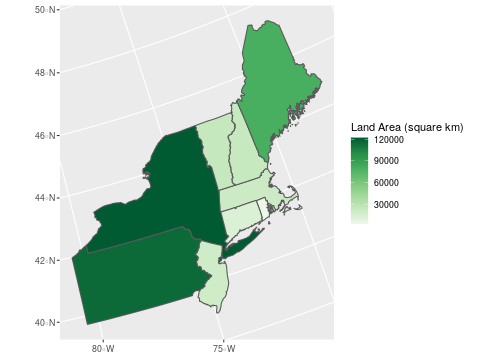
class: center, middle, inverse, title-slide # Working with Geospatial Data ## Joining spatial data ### Ben Baumer ### SDS 192</br>April 15th, 2020</br>(<a href="http://beanumber.github.io/sds192/lectures/mdsr_geo_09-joins.html" class="uri">http://beanumber.github.io/sds192/lectures/mdsr_geo_09-joins.html</a>) --- class: center, middle, inverse # [Spatial joins](http://wiki.gis.com/wiki/index.php/Spatial_Join) --- ## Two ideas .pull-left[ - Joining based on **attributes** - `sf` object + `data.frame` object - add new variables - `inner_join()`, `left_join()`, etc. ] .pull-left[ - Joining based on **geometries** - `sf` object + `sf` object - make new geometries - `st_join()` - `left = TRUE/FALSE` - `join` predicates: - `st_within`, `st_crosses`, `st_intersects`, etc. .footnote[http://wiki.gis.com/wiki/index.php/Spatial_Join] ] --- ## Make a choropleth of the Northeast ```r library(tigris) library(sf) us <- states(cb = TRUE, class = "sf") ``` -- ```r state_region_lkup <- tibble( postal_code = state.abb, region = state.region ) ``` -- ```r class(us) ``` ``` ## [1] "sf" "data.frame" ``` ```r class(state_region_lkup) ``` ``` ## [1] "tbl_df" "tbl" "data.frame" ``` --- ## Attribute (non-spatial) join ```r nrow(us) ``` ``` ## [1] 56 ``` ```r nrow(state_region_lkup) ``` ``` ## [1] 50 ``` -- ```r ne <- us %>% left_join(state_region_lkup, by = c("STUSPS" = "postal_code")) %>% filter(region == "Northeast") nrow(ne) ``` ``` ## [1] 9 ``` --- ## Land area in the Northeast .pull-left[ ```r ne_plot <- ggplot(ne) + geom_sf( aes(fill = ALAND / 1e6) ) + coord_sf(crs = st_crs(2163)) + scale_fill_distiller( "Land Area (square km)", palette = "Greens", direction = 1 ) ``` .footnote[https://epsg.io/2163] ] -- .pull-right[ <!-- --> ] --- ## Spatial join ```r library(macleish) macleish <- macleish_layers %>% pluck("boundary") ``` -- ```r ne %>% * st_join(macleish) ``` ``` ## Error in st_geos_binop("intersects", x, y, sparse = sparse, prepared = prepared): st_crs(x) == st_crs(y) is not TRUE ``` -- ```r ne %>% st_crs() ``` ``` ## Coordinate Reference System: ## User input: 4269 ## wkt: ## GEOGCS["GCS_North_American_1983", ## DATUM["North_American_Datum_1983", ## SPHEROID["GRS_1980",6378137,298.257222101]], ## PRIMEM["Greenwich",0], ## UNIT["Degree",0.017453292519943295], ## AUTHORITY["EPSG","4269"]] ``` --- ## Convert to common CRS first! ```r ne %>% st_transform(4326) %>% * st_join(macleish, join = st_contains, left = FALSE) ``` ``` ## although coordinates are longitude/latitude, st_contains assumes that they are planar ``` ``` ## Simple feature collection with 1 feature and 13 fields ## geometry type: MULTIPOLYGON ## dimension: XY ## bbox: xmin: -73.50814 ymin: 41.23796 xmax: -69.92839 ymax: 42.88659 ## CRS: EPSG:4326 ## STATEFP STATENS AFFGEOID GEOID STUSPS NAME LSAD ALAND ## 1 25 00606926 0400000US25 25 MA Massachusetts 00 20205125364 ## AWATER region OBJECTID Shape_Leng Shape_Area ## 1 7129925486 Northeast 1 5893.578 1033988 ## geometry ## 1 MULTIPOLYGON (((-70.23405 4... ``` --- ## Can change join predicate! ```r ne %>% st_transform(4326) %>% * st_join(macleish, join = st_within, left = FALSE) ``` ``` ## although coordinates are longitude/latitude, st_within assumes that they are planar ``` ``` ## Simple feature collection with 0 features and 13 fields ## bbox: xmin: NA ymin: NA xmax: NA ymax: NA ## CRS: EPSG:4326 ## [1] STATEFP STATENS AFFGEOID GEOID STUSPS NAME ## [7] LSAD ALAND AWATER region OBJECTID Shape_Leng ## [13] Shape_Area geometry ## <0 rows> (or 0-length row.names) ``` .footnote[https://r-spatial.github.io/sf/reference/st_join.html]